Introduction
In this Webquest, you will learn how geography affected trading in African Kingdoms. You will learn the obstacles that had to be avoided during trading. You will be able to identify the regions inside Africa and know about each climate zone. You will learn about the resources and developments that each region traded. You will also learn which route and form of transportation was used in each African region.
Task
To learn about Africa and to be able to answer your Webquest questions, you must click on each link provided in this exercise. You must read all summeries provided and watch each video completely. You must answer all the questions in order. I expect everyone to work alone, complete this exercise by next Friday, and be able to draw a poster to explain what you have learned. I suggest doing 1 lesson each day. After you have completed all of the work, answered all of the questions, and completed your poster, you should review the rubric to be sure you have not skipped anything.
Add all of your answers to this Webquest and to your poster.
You may use your phones/ electronic devices to look up answers for Lesson 6. You may not look on any websites before reading and watching all the provided links first. You may also use your textbook.
Process
Lesson 1= Identify each region inside Africa during the 1600's. This map should be drawn on your poster with each region labeled (5 regions total, See Chapter 16). Write the name of each region, a short descripion of the climate and land, and which kingdom occupied each region on your poster.
Reading link (use 3rd picture to find where the Ghana, Mali, and Songhai lived)=http://www.lrwieland.com/pboothe/Magnet-World-History-03-04/World%20History%20Magnet/2004_2005_MAIN/Six_Weeks_Documents/3rd_Six_Weeks/Americas_Africa.htm
Pictures to refer to= HERE (More pictures are below and in your textbook.)
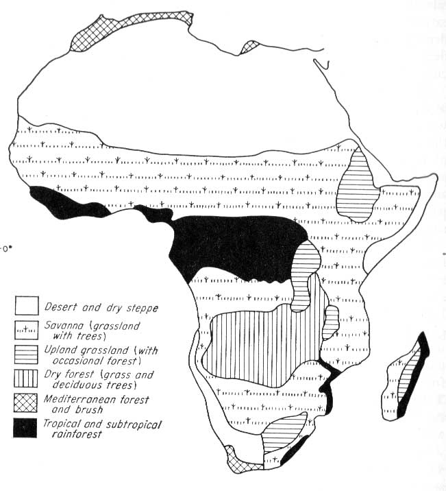

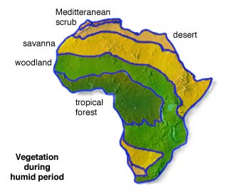
List these in order from North to south:
1. Sahel
2. Savanna
3. Mediterrarean
4. Sahel (Yes, know it is listed twice. You will label two areas on your map with this title.)
5. Desert
6. Forest
Lesson 2= List the two main resources that were traded in Africa. Use this link. Add this information to your poster somehow. Be creative!
7.
8.
Lesson 3= Use these videos to answer the following questions about Africa. Add to your poster.
video 1= link
[video:https://www.youtube.com/watch?v=RUZxZiNIWqc]
video 2= link
9. What were the main resources traded for? _______________________________
10. What kingdom in Africa did this trading take place in? ___________________________
11. What is another name for the gold-salt trade? ____________________________
Lesson 4= Use this webpage and this webpage to decide what might be some trading obstacles in each region. Read and watch the video! Think Climate!!!
Add obstacles a trader my be faced with while traveling in each zone. How might they overcome these obstacles? (HINT: Think travel! Tsetse Flies in the rainforest causes travelers to leave their animals outside of the rainforest and then travel on foot.) Add this information and information on how one might travel in each African zone to your poster.
Lesson 5= Now it's time to learn about other resourses. Please find out which zone and/or kingdom had these following resources. Your textbook is a great resource for this lesson. Complete the followin section and add these facts to your poster.
12. Gold= __________
13. Salt= __________
14. Cattle/ Donkeys= _________
15: Kola Nuts= __________ (BONUS: Why?)
Lesson 6= Use your phone or tablet to look up the Niger River in Ancient Africa. Draw the river on your poster and answer the following questions. The river runs through three zones and almost reaches the a forth zone. Keep this in mind when adding the river to your poster. Watch this video to learn more about the Nigal River.
16. What did the African people use the Niger River for mainly?
17. If there was a river, why was the desert so dry?
18. What main resource did the river help transport?
Evaluation
Rubric= You may earn a total of 100 points for this project.
Your poster is colored, neat, and organized= 10 points
Your poster is turned in on time (Friday, April 15th, at the beginning of class)= 10 points
18 questions are completed on webquest, the answers are correct, and your answers were found from the corresponding links= 10 points
Africa is drawn and labeled on your map poster= 10 points
6 regions, 6 climates, and 3 kingdoms are labeled on your map in the correct areas of your Africa drawing= 10 points
4 resources are labeled on your map in the correct zone= 10 points
How one might have traveled in each zone is labeled or drawn on your map= 10 points
The traveling obstacles the African traders faced in each climate zone are listed on your poster= 10 points
The Niger River is drawn on your map of Africa in the correct place= 10 points
Name, date, and class period is written on the back of your poster= 10 points
Conclusion
I hope you learned a lot about Ancient Africa, the caravan trading, and the African climate through this Webquest activity. I hope you liked learning through online resources. I made sure to included all the upcoming Chapter 16 topics in this activity. After you have completed your African Trading and Climate poster, you should be able to answer the following questions.
Why did people move to Africa during this time?
Which resources were the most valuable?
How did the climate affect trading in Ancient Africa?
You already know about the Silk Road and you should now be able to describe how the Niger River contributed to the trading routes.
If you were not able to fully answer the above questions, please click on the following link to review for Chapter 16.
Credits
Teacher Page
6-4.2 Describe the influence of geography on trade in the African kingdoms, including the salt and gold trades.