Introduction
The following portal involves an online Comparative Study program.
This focus of this particular study incorporates the HSC topic of Urban Places.
Immerse yourself in a virtual study that illustrates comparative case analysis between Sydney and London World Cities
Activities will allow you to apply business concepts and understanding as well as problem solving capabilities toward the focus topic. You will also take part in a presentation to develop understanding of project-based learning approaches which is linked exclusively to this comparative study.
By the end of this program, you will be able to form relationships and linkages between the syllabus content related to Urban Places and the online comparative study.
Best wishes and enjoy your experience
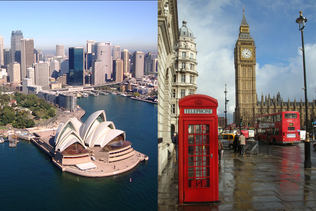
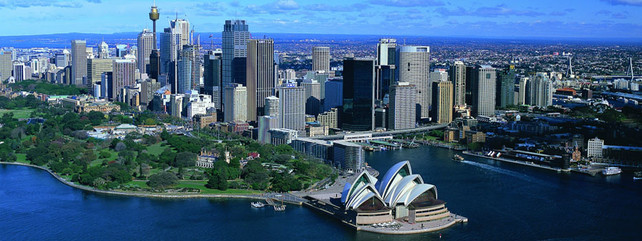
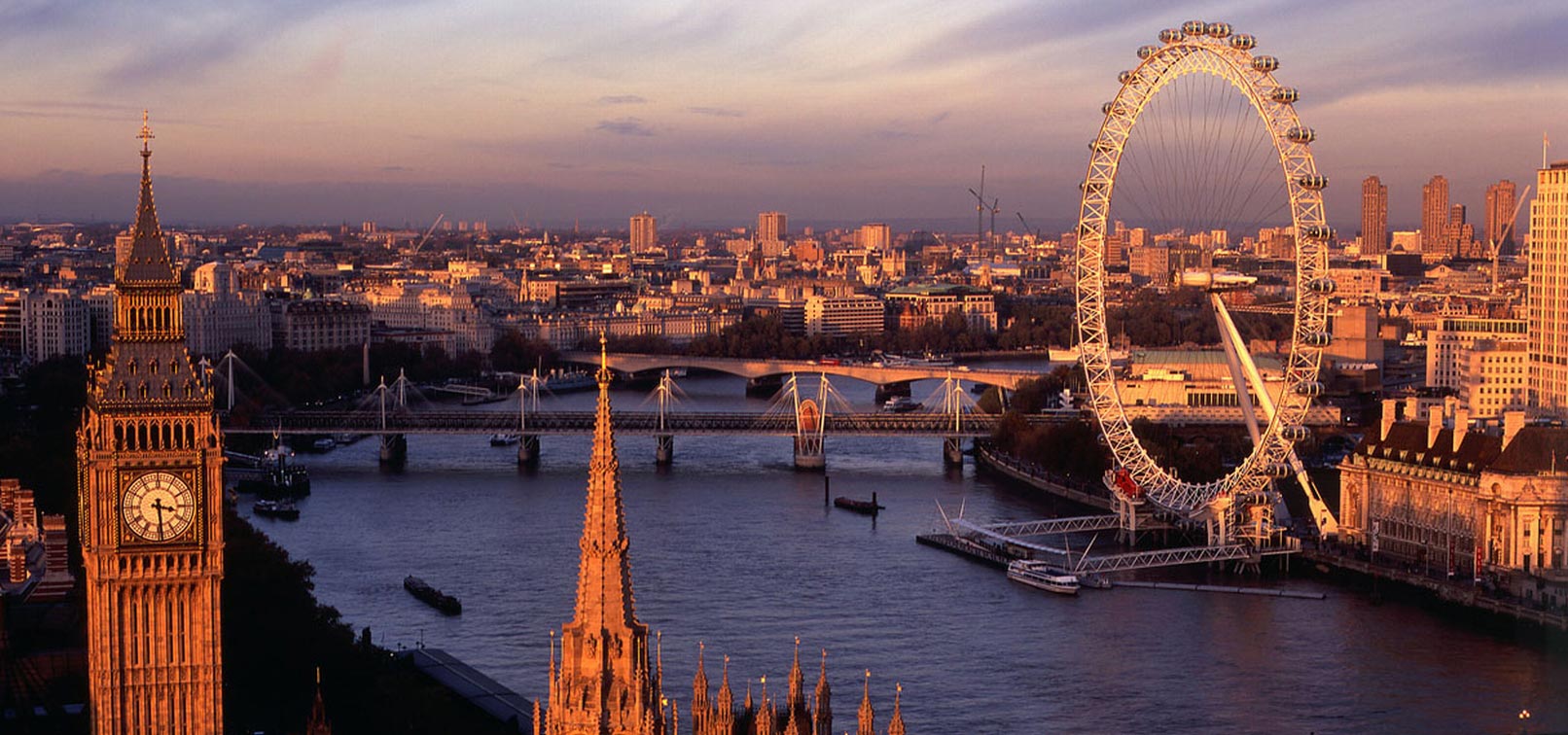
SYDNEY VS LONDON
Task
You have been chosen to take part in our Online Comparative Study. This program will provide you with suggested resources to develop understanding of how two world cities (Sydney and London) contain comparable geographical inquiries. The following program will also illustrate how world cities, mega cities demonstrate changing spatial patterns and geographical patterns, processes and trends through urban dynamics.
We require expert analysis on the appropriateness of strategies in dealing with the challenges of contemporary urban dynamics existing between mega and world cities.

Process
WORLD CITIES
Online Comparative Analysis - Sydney vs London
World cities’ are a highly competitive, global network of cities. They involve major centres of transnational corporations (TNC’s); where the most important financial and corporate institutions are located and where decisions that ‘drive’ the global economy are made.
The following suggested background readings will assist you in completing this study. In addition, further Internet research is required.
https://smccyr12geography.wikispaces.com/file/view/Sydney%20case%20stud…
http://moodle.bpslism.catholic.edu.au/pluginfile.php/50423/mod_resource…
https://smccyr12geography.wikispaces.com/file/view/culure%20and%20langu…
LESSON 1 ROLE OF WORLD CITIES
Recall that a World City is based on a global perspective and reveals how a city cannot just be studied in isolation; but has to be understood as belonging to a network of cities that stretches across the world.
Activity 1 (time allowed: 10mins)
The purpose of this activity is to explain the role of world cities in a cultural and economic context
Explain (in your own words) the ROLE of world cities in a cultural and economic context (i.e. reasons why cultural and economic contexts are important)
Activity 2 (time allowed 20mins)
The purpose of this activity is to use concept development skills to illustrate the features that classify Sydney and London as World Cities
a) Watch the following youtube videos
https://www.youtube.com/watch?v=Af6_kRndzY4 - Sydney: A world city
https://www.youtube.com/watch?v=BMUIDrd-mxI - London: A world city
b) Based on the videos, using cmap tools - construct a concept map on what you observe to be the elements that make Sydney and London World Cities
Note: upload an image of the concept map to this portal
Activity 3 (time allowed 30mins)
The purpose of this activity is to explore features, evidence and examples of the economic and cultural characteristics of Global Sydney and Global London
By observing the example below, you are to construct a table that mirrors the one below and insert and explain ALL the economic and cultural elements for Global Sydney and Global London
|
Features / evidence that determine a world city of cultural authority |
Elaborate (SYDNEY) |
Examples / statistics to support (SYDNEY) |
Elaborate (LONDON) |
Examples / statistics to support (LONDON) |
|
Art and museum focal centres |
Sydney has a large range of art galleries and museums that illustrate cultural, historical and religious artefacts, imagery and documents |
Art Gallery, Powerhouse Musuem, Musuem of Contemporary Art |
|
|
Economic elements
- Headquarters of TNC’s
- Infrastructure incl buildings, transport, utilities e.g hospitals and medicine
- Specialised service firms / intellectual business
- Technology and communications
- GDP per capita
- Employment opportunities
- Level of Research & Development
- Level of Direct Foreign Investment
Cultural elements
- Special events e.g Mardi Gras / pink tourism
- Host World Cup events/Olympic games
- Religious focal centres
- Art and museum focal centres
- Historical centres
LESSON 2 REGIONAL AREAS/SMALL TOWNS
Activity 1 (time allowed: 15mins)
Recall Urbanisation describes the increasing proportion of people living in urban areas (cities) as opposed to small towns or rural areas
Recall also that the main cause of Urbanisation is rural-urban migration
•In 1800 only 3% of the world's population lived in cities.
•By the end of the 20th century 47% lived in cities.•The UN forecasts that today's urban population of 3.2 billion will rise to nearly 5 billion by 2030, when three out of five people will live in cities
The purpose of this activity is to explore population and service changes from regional areas to small towns
The table below illustrates the increase of urbanisation (increase of people moving to towns and cities) in a global scale
|
|
Urban world population |
||||
|
|
1800 |
1900 |
1950 |
2010 |
2030 |
|
WORLD |
3% |
14% |
30% |
50.5% |
60% |
a) Your task is to create a table (similiar to the one above) and list using statistics, changes in the urban population of Global Sydney and Global London
b) Explain the changes over time (in your own words) for Sydney and London
Activity 2 (time allowed: 45mins)
The purpose of this activity is to evaluate the implications of a world city in relation to population movements
a) Evaluate (using examples) how Sydney has been affected by changes in population and services from small towns to regional centres (i.e. how TNC's, economic restructuring, globalisation and technology has influenced these changes)
b) Evaluate (using examples) how Sydney has been affected by changes in population and services from small towns to regional centres (i.e. how TNC's, economic restructuring, globalisation and technology has influenced these changes)
LESSON 3 URBAN DYNAMICS IN A LARGE CITY
Activity 1 (time allowed: 40mins)
Spatial patterns of advantage and disadvantage deal with the unevenness and spatial inequalities relating to 'income', 'ethnicity' and 'education attainment/occupation' within a city. Social ranking and class dictates where people live, work and interact within their environment.
The purpose of this activity is to develop an understanding of the factors that contribute to the unnevennes in socio-economic opportunities in GLOBAL SYDNEY
Task 1 Refer to the chloropleth maps below on Unemployed people as a percentage of the labour force (Figure 1) and Households with gross weekly income less than $500 as a percentage of all households (Figure 2)

Figure 1: Unemployed people as a percentage of the labour force
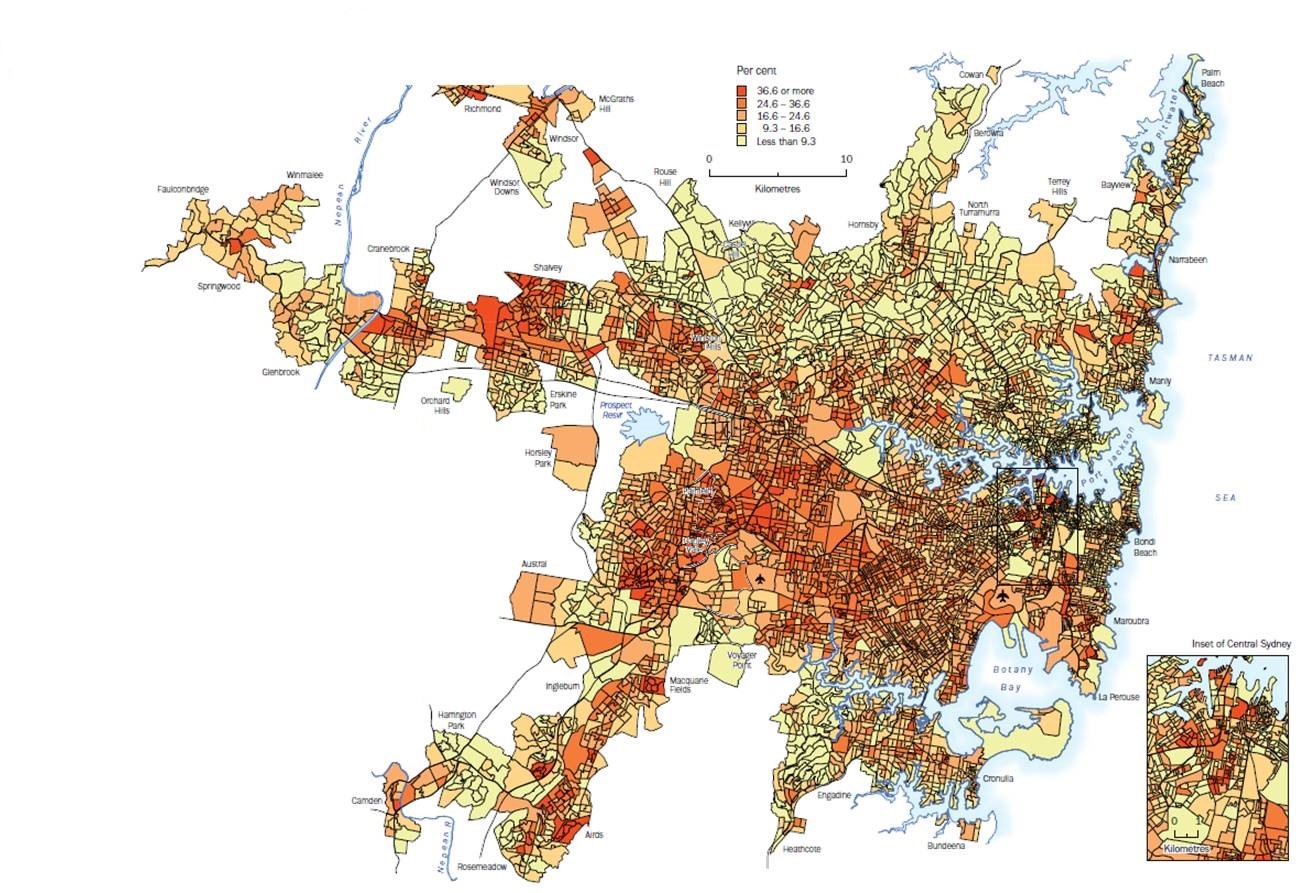
Figure 2: Households with gross weekly income less than $500 as a percentage of all households
a) Compare the spatial pattern of Household income (Figure 2) to the map of Unemployment (Figure 1). Does the map share the same spatial pattern as unemployment (i.e. do the areas of high and low concentration match)? Describe the similarities and differences in the spatial pattern.
b) Explain why the map of Household income shares (or does not share) a similar spatial pattern to the map of unemployment (i.e. services, employment etc)
Task 2 Refer to the chloropleth map below on People aged 5 years and over who did not speak English well or at all as a percentage of the total population aged 5 years and over (Figure 3)
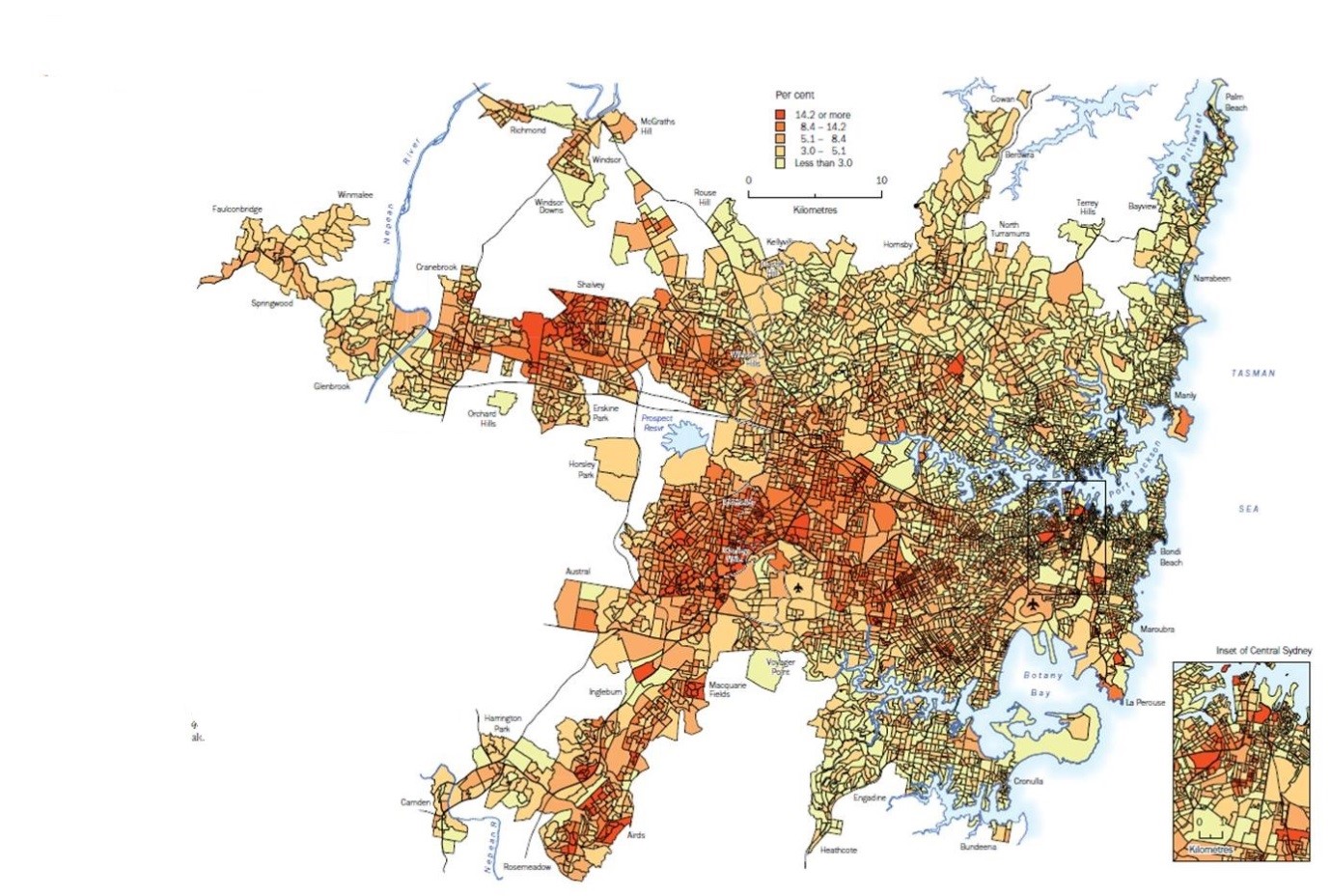
Figure 3: People aged 5 years and over who did not speak English well or at all as a percentage of the total population aged 5 years and over
a) Compare the spatial pattern of People who didn't speak English well (Figure 3) to the map of Unemployment (Figure 1). Does the map share the same spatial pattern as unemployment (i.e. do the areas of high and low concentration match)? Describe the similarities and differences in the spatial pattern.
b) Explain why the map of People who didn't speak English well shares (or does not share) a similar spatial pattern to the map of unemployment (i.e. services, employment etc)
Task 2 Refer to the chloropleth map below on People with University qualifications as a percentage of the Labour force (Figure 4)
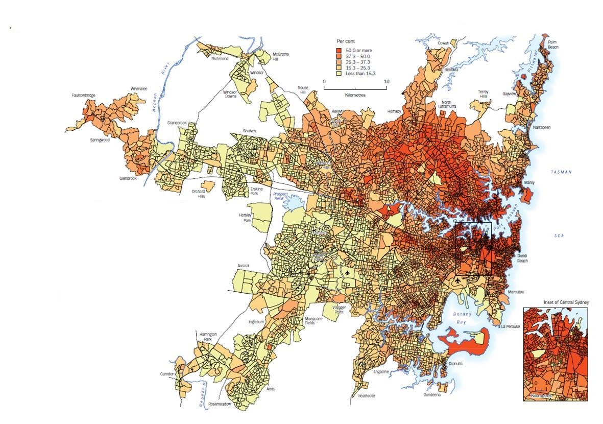
Figure 3: People with University qualifications as a percentage of the Labour force, Sydney
a) Compare the spatial pattern of People with University qualifications (Figure 4) to the map of Unemployment (Figure 1). Does the map share the same spatial pattern as unemployment (i.e. do the areas of high and low concentration match)? Describe the similarities and differences in the spatial pattern.
b) Explain why the map of People with University qualifications shares (or does not share) a similar spatial pattern to the map of unemployment (i.e. services, employment etc)
Activity 2 (time allowed: 20mins)
The purpose of this activity is to compare and contrast the spatial patterns of advantage and disadvantage in large cities across the world
The chloropleth maps illustrated above show that some areas of Sydney experience varying levels of unemployment, income, access to education compared to the rest of Sydney. This suggests that population movements and location of persons emphasise unneveness in socio-economic opportunities
Task 1 Evaluate the spatial patterns of advantage and disadvantage within a large city in Sydney: (i.e. Pyrmont, Bankstown, Cabramatta or Blacktown)
Task 2 Using research, compare and contrast the spatial patterns of advantage and disadvantage in Sydney with another large city of your choice in any country
Note: a large city does not necessarily mean a mega city
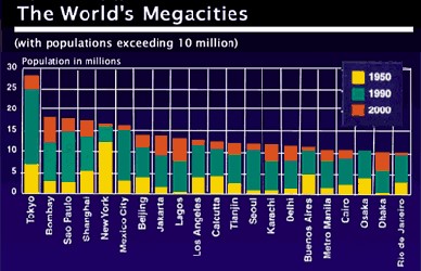
LESSON 4 MEGA CITIES
Activity 1 (time allowed: 20mins)
Recall megacities are generally defined as a metropolitan area with a total population in excess of 10 million people
The purpose of this activity is to compare the rapid growth of two megacities in the developing world
Task 1 Select TWO megacities (of your choice) and account for (give reasons) the rapid growth of these megacities in the developing world (i.e. reasons for global expansion; push/pull factors)
Note:
Task 2 Upload at least ONE graphic/image for both chosen megacities, illustrating reasons for this rapid growth
Activity 2 (time allowed: 20mins)
The purpose of this activity is to compare the challenges of provisional services located in two megacities in the developing world
Task 1 Illustrate (by uploading images/graphics) at least TWO challenges that deal with services located in your two chosen megacities
Task 2 Based on these illustrations,
a) Evaluate these challenges associated with the provision of services in your two chosen megacities (i.e. use examples and refer to your images to highlight and explain the impacts of these challenges)
(use a comparison chart in microsoft word to complete your response, and upload it to this portal)
b) Evaluate the responses to these challenges in your two chosen megacities
(Note: refer to NGO's and support services in your answer)
Activity 3 (time allowed: 10mins)
The purpose of this activity is to account for the changing nature, character and spatial distribution of mega cities, using essay response format
Task1 Using a mind map format, scaffold the following question:
Account for the changing nature, character and spatial distribution of your two chosen mega cities
Task 2 Compare findings with your group and prepare for the presentation to be performed in the first post-lesson
Evaluation
Individual Online Comparative Study Marking Criteria
Student Name: ___________________
|
Criteria |
Mark |
|
17 – 20 |
|
13 – 16 |
|
9 – 12 |
|
5 – 8 |
|
1 – 4 |
Conclusion
Congratulations! You have reached the completion of your Online Comparative Study.
You have now acquired the knowledge of Urban Places and strategic skills in problem solving and ability to engage in real-world learning contexts using this amazing online virtual tool.
As a result, you are now an expert in Urban comparative analysis.
I thank you for participating and i hope you enjoyed your experience.