Introduction
This WebQuest is a virtual fieldwork study of Australia’s Coastal Plains. You will explore Australia’s Major Landforms and Drainage Basins by completing your own internet research. You will then go on a virtual tour of a City that lies on Australia’s South-East Coast. Your virtual fieldwork will lead you to discover Kiama’s natural features landforms and Kiama’s built environment.
Your Virtual Fieldwork is located on the following site:
http://coastalplainskiama.weebly.com/
Task
You have been set the task of exploring Australia’s Major Landforms and Drainage Basins by completing your own internet research. You will then go on a virtual tour of a City that lies on Australia’s South-East Coast. Your virtual fieldwork will lead you to discover Kiama’s natural features landforms and Kiama’s built environment. You will be required to explore the positive and negative effects of Kiama’s built environment on its natural environment. Don’t forget that YOU ARE GEOGRAPHERS. When you look at a video or a photo, you should be analysing that image with the mind of a Geographer.
Goodluck and Have FUN!!!
P.S. Don’t forget to SAVE YOUR WORK when you log off.
Process
Open a Word Document and Save it with the Heading – “Kiama: South-East Coast: Virtual Fieldwork”. You will be answering all of the questions on your Word Document.
Ready, Set, Go!!
Australia's Major Landforms and Drainage Basins
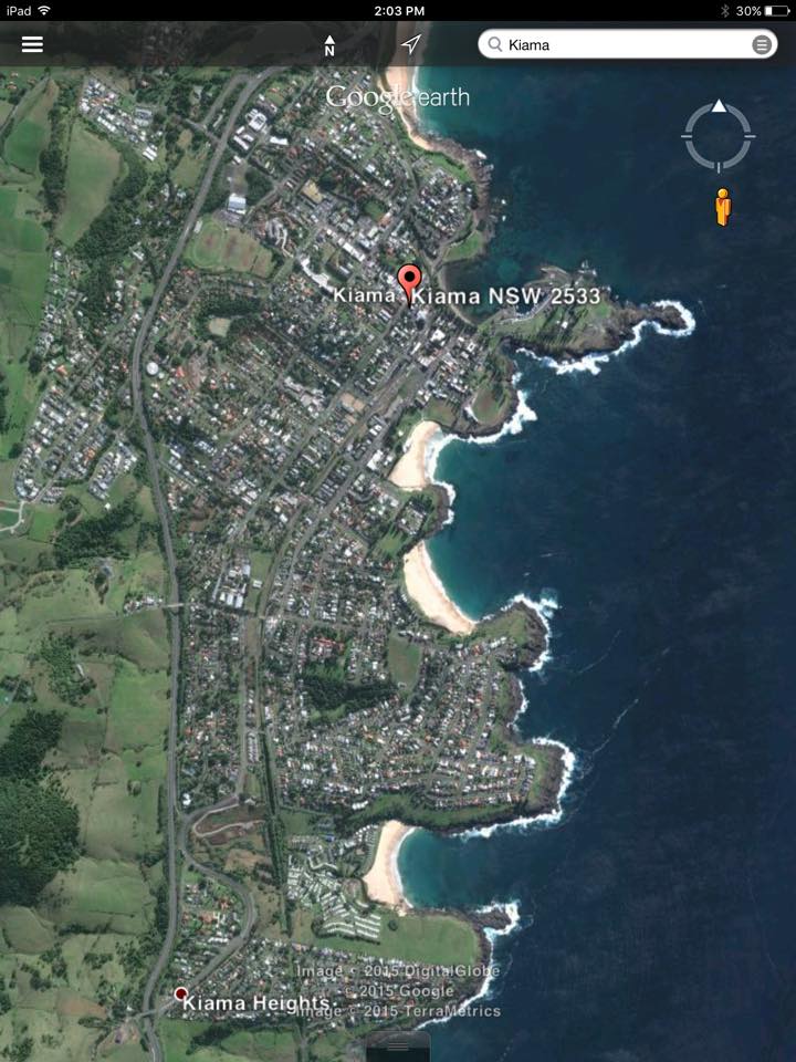
1. You are to locate Kiama on a map of Australia.
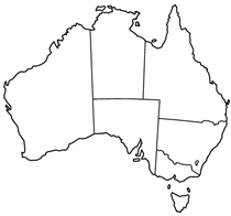
https://commons.wikimedia.org/wiki/File:Australia_states_blank.png
You will use Google Maps to help with this.
https://www.google.com.au/maps
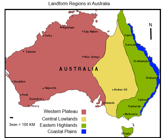
2. In which major landform region would you locate Kiama?
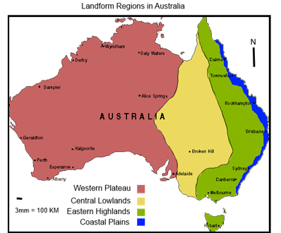
http://theaew.weebly.com/uploads/1/2/1/1/12116484/182501_orig.png
http://melahamytheaustralianenvironment.weebly.com/uploads/1/7/4/6/1746…
Use Google Maps or existing knowledge of Kiama’s location.
https://www.google.com.au/maps
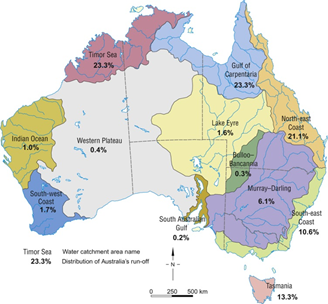
3. Which major drainage basin is Kiama a part of?
Use Google Maps or existing knowledge of Kiama’s location.
https://www.google.com.au/maps
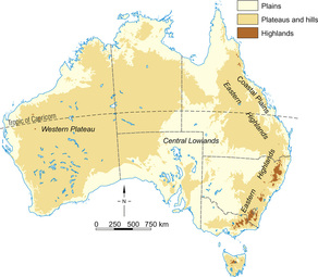
4. Using the internet, provide a brief description of Australia’s four main landform regions.
5. Using the internet and/or the previous two images, Identify Australia’s largest drainage basin.
6. List the three main natural forces that lead to the formation of landforms?
Suggested Sites:
http://regentsprep.org/regents/earthsci/units/weathering/landforms.cfm
http://www.tutorialsolutions.com/esWEDNotes.htm
7. Explain which processes (forces) you consider to be most influential in the formation
of Australia’s landforms.
8. You are to locate the Aboriginal Nation/s that were located in the vicinity of modern day Kiama.
You are to use the previous activities or Google maps and the Website provided below.
http://www.curriculumsupport.education.nsw.gov.au/shared/abmaps/nsw.htm
9. Using internet research, complete the following Glossary Definitions List.
Climate:
Drainage Basin:
Drought:
Ecosystem:
Endemic:
Isobar:
Marsupial:
Monotreme:
Monsoon:
Reolith:
Species:
Synoptic Chart:
Topographic Map:
10. How much rainfall did Kiama approximately recieve between October 1 2014 and September 30 2015?
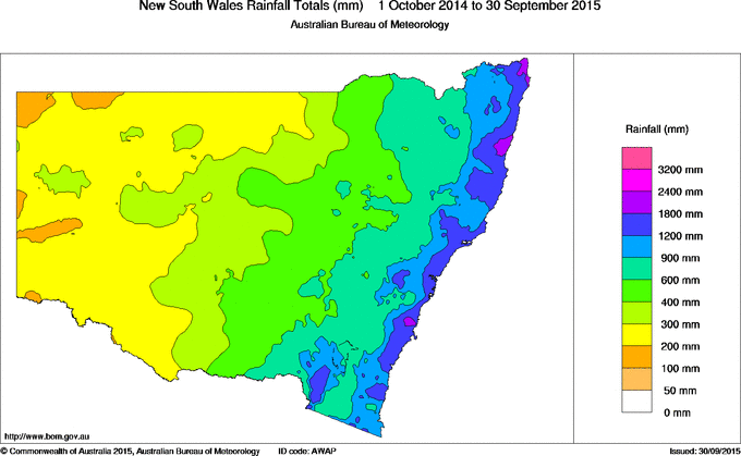
http://www.bom.gov.au/jsp/awap/rain/index.jsp
11. What was the approximate maximum temperature of Kiama between October 1 2014 and September 30 2015?
.gif)
http://www.bom.gov.au/jsp/awap/temp/index.jsp
12. What was the approximate mean temperature of Kiama between October 1 2014 and September 30 2015?
.gif)
http://www.bom.gov.au/jsp/awap/temp/index.jsp
13. Compare this temperature to the rest of Australia. What trends do you notice and what do these trends reveal about the climate in Kiama?
.gif)
http://www.bom.gov.au/jsp/awap/temp/index.jsp
Virtual Fieldwork: Kiama
1. Using the Virtual Fieldwork, you are to draw a field sketch of one chosen place you wish to focus on.
Suggested Site:
http://coastalplainskiama.weebly.com/
http://pcwww.liv.ac.uk/geo-oer/index_htm_files/Field%20sketches%20&%20how%20to%20draw%20them.pdf (Recap – What is a Field Sketch?)
2. Locate 3 landmarks at Kiama. Use both your Virtual Fieldwork and internet research.
These must include both natural AND manmade.
Suggested Sites:
Google Maps https://www.google.com.au/maps
http://coastalplainskiama.weebly.com/
3. You are to create a profile for each landmark.
Landmark:
Manmade or Natural:
Location:
Function:
Interesting Fact:
4. Using your Virtual Fieldwork, create a profile for one animal that is present at Kiama.
Who am i:
Where am I most commonly found:
Short description:
Am I Native to Australia:
Suggested Site:
http://coastalplainskiama.weebly.com/
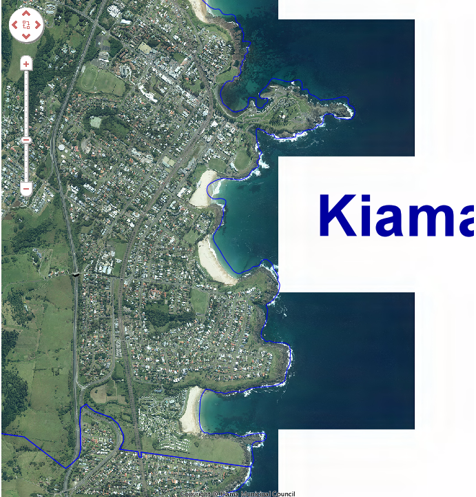
5. Using the interactive map provided, answer the following question.
Is Kiama relatively flat? Explain.
http://www.kiama.nsw.gov.au/planning-and-development/view-maps/interact…
Hint:
6. Using the two photos provided, compare the similarities and differences between Kiama in 2005 to 2015.
 2005
2005
 2015
2015
7. What type of pollution is present in your virtual fieldwork?
8. What intervention strategies could be used to fix this? You will need to conduct your own internet research.
Suggested Site:
http://coastalplainskiama.weebly.com/
9. What types of businesses are present in your Virtual Fieldwork?
10. What effects might they have on the surrounding environment? Use your personal knowledge and internet research to answer this question.
11. Using your Virtual Fieldwork and internet research, Describe how a blowhole works.
Sugessted Sites:
http://coastalplainskiama.weebly.com/
http://www.kiama.com.au/blowhole
http://biblicalgeology.net/blog/the-blowhole-kiama/
12. Using your own research and the website provided, note the changes to Kiama that have occurred over time. This could be both natural and physical.
Hints:
You may look at changes to:
- Development
- Population
- Vegetation
- Natural Land
- Animals
13. Using the link to the Kiama Municipal Council, provide a list and general overview of
different ways in which Kiama Municipal Council is striving to achieve a
sustainable environment.
Hint: this is a sustainable management plan to support tourism in Kiama on a LOCAL scale.
14. Using Table 9.1. (page 93-97) of the Website provided, list five tourist attractions or activities that enhance tourism in Kiama.
Hint: this is a sustainable management plan to support tourism in Kiama on a LOCAL scale.
15. Suggest how each of these activities/attractions could lead to pollution.
16. Suggest how each of these activities/attractions could lead to negative or positive human interaction.
17. List the positive and negative aspects of Human Interaction at Kiama. Use both your Virtual Fieldwork and internet research to enhance your answer.
Think Local, National and Global.
http://coastalplainskiama.weebly.com/
Evaluation
Assessment Task Two: Research Action Plan
Task:
Complete and submit the virtual fieldwork booklet in class to make up the first part of this assessment. You are then required to write a Research Action Plan on the Effects of Human Interation on Australia’s South-East Coast. Students may wish to focus on Kiama as this would be easiest incorporating the virtual fieldwork.
Students are required to create a Research Action Plan with reference to their Virtual Fieldwork WebQuest.
As prescribed by the BOS NSW Geography Years 7–10 syllabus 2003, the RAP involves the following steps:
1. Identify the aim/purpose of the investigation.
2. Generate a number of focus questions to be addressed by the investigation.
3. Decide which primary and secondary data are needed to answer the focus questions.
4. Identify the techniques that will be used to collect the data.
5. Collect primary and secondary data.
6. Process and analyse the data collected.
7. Select presentation methods to communicate the research findings effectively.
8. Propose individual or group action in response to the research findings and, where appropriate, take such action.