Introduction
Good afternoon everybody,
Question: Who has ever been lost in a city?
-
Well, we both have and since getting lost is a waste of your time, we are going to prepare you for your trip in London. In todays lesson you will learn:
-How to find your way in London using a map
-Getting to know the most important sights of London
-How to find your way back when you are lost
-
As you know, in two weeks time we will go on a field trip to London for 3 days!

Task
Webquest:
Task 1: Map of London
First you are going to look at a map of london, and some of the most important buildings.
Task 2: Sights to see
You will make a top 5 of places you would like to visit, and describe why you would like to go there. You will write at least 3 sentences in a google/word document.
Task 3: Plan a tour
You have to highlight 2 of the places from Task 2, then you use google maps to plan a route between these places and look for a place where the class can have lunch. Make sure the distance the group has to walk is realistic. We don't want to walk 2 hours to get from one place to the next.
You will post a description of your tour, together with a link to google maps, in the facebook group.
Task 4: GeoGuessr
You will visit the website of GeoGuessr (London), this is a game where you will be dropped at a random location in London on google maps (street view).
You then have to look around for clues which help you find your location on the map.
Use google to find information on where you are, and then pinpoint your starting position.
Extra challange: do not use google for finding your way!
You can do this up to 5 times and post your score in the GeoGuessr conversation in the facebook group.
Process
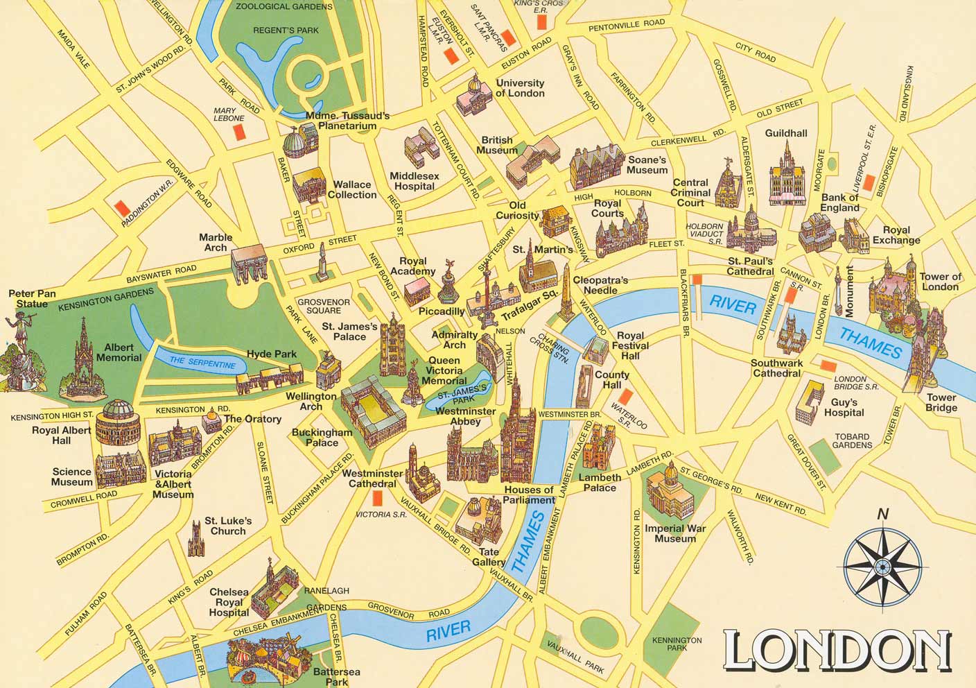
Task 1: Map of London
You can find a bigger version of this map at:
http://www.myenglandtravel.com/maps-of-England/London_Tourist_attractio…
Task 2: Sights to see
Go to google and search for words like:
- Sightseeing in London
- London top attractions
- London Tours
- Write a top 5 of the places you have found, in a google/word doc. For each site, write at least 3 sentences as a description.
-
Task 3: Plan a tour
- Pick 2 of the sites from Task 2 and go to https://maps.google.com and click on direction
- Enter the two sites you would like to see and let google calculate a route between them
- Make sure you set the route to walking or maybe a bike, we will not be using cars!
- Look at the walking route and find a place to eat on, or close to, the route you have set out
- Add the place to your walking route and check if the total distance is realistic for a group to walk
- Write a description of your sightseeing-tour (in google/word docs or directly on Facebook)
- You will post a description of your tour, together with a link to google maps, in the facebook group.
- The description of your sightseeing-tour has to be between 200 and 300 words
- Make a new post at https://facebook.com/groups/849258828519228/
-
Task 4: GeoGuessr
- Go to https://geoguessr.com/london/play
- Use your own knowledge of London to pinpoint where you are
- You are allowed to use google as an extra tool, but we challenge you to do it without!
- Use the flag icon to return to your original position, this is the position you have to guess
- Post your final score on the GeoGuessr thread in the facebook group
Evaluation
Post your route (task 3) on: https://www.facebook.com/groups/849258828519228
-
Criteria
- 200-250 words
- Use of English
- Grammar
- At least two places to visit and one place to eat
- It has to be realistic
Conclusion
Today you have learned how to look up the main sights in London, how to make a route and how to find your way in London.
=
We hope that you will visit these places. If so, please post your photos on the Facebook page.
-
Let's hope you don't get lost, but if you do you at least know some things on how to pinpoint where you are!
Credits
Geoguessr
Webquest
Google maps
Not made impossible by us
Teacher Page
For this activity we chose the SAMR model. SAMR stands for different technological levels of use: Substitution, Augmentation, Modification, Redefinition (Puentedura, 2001)
We applied the SAMR model as follows:-
S. Tech acts as direct tool substitute, with no functional change:
We showed a map of London featuring the most important buildings, pupils could zoom in on this map and read the street names. Pupils are asked the names and functions of some of these buildings, activating previous knowledge.
A. Tech acts as a direct tool substitute, with functional improvement:
We let the pupils search information on the top 5 places they would like to visit and write a short description of each. The search engine is a functional improvement because it lets the pupils look at everything there is to do in London. The pupils get a lot of free choice in this matter.
M. Tech allows for significant task redesign:
The pupils can look up the actual distances and walking times of different routes from one place to another. Pupils plan a route and take into account that there needs to be a stop for some food. Many restaurants are displayed on google maps which helps with making a logical choice.
R. Tech allows for the creation of new tasks, previously inconceivable:
Being dropped at multiple random locations, while being safe. Geoguessr makes possible what was very inconceivable.