Introduction
Welcome to your virtual fieldwork.
This study will focus on Australia's physical environment of the iconic Bondi beach. This coastline will be used to investigate and assist you in completing the virtual activities. You will engage critically with virtual activities of mapping, sketching, videos, analysing and answering questions, which will prepare you to understand and apply geographical issues based on physical characteristics of natural environments.
Good luck and remember to have fun!

Task
[video:https://www.youtube.com/watch?v=siyV8N-DxIo]
It is time to bring out the geography experts within you and to make you even better geographers you will be going on a virtual fieldwork based at the unqiue area of Bondi to Coogee coastline.
You are required to answer and complete all the questions and activities in the four virtual lessons, and save them in a Word document. Keep all your work as they will assist you with future tasks. Through these actvities you will be collecting primary and secondary data to identify, describe and represent physical features and patterns using geographical tools such as maps and sketeches. You will also need to analyse the environment of this location and how it may have an impact on humans and how humans may impact the environment.
Process
Lesson 1- Physical characteristics
Watch the videos and complete the activities.
[video:https://www.youtube.com/watch?v=arFTh56-DVA]
Read the article to give you some background on this particular landform.
http://www.environment.gov.au/cgi-bin/ahdb/search.pl?mode=place_detail;…
Activity 1. Produce a fieldsketch of the coastline with labels and annoations, scan and save it in your Word document. Label as many features as you can.
You may use 'Cam Scanner App' to save your work and transfer it on to your Word document.
Activity 2. Save and copy/paste a map using Google maps and Google Earth to identify features and create a profile.
Identify and locate:
- What is it?
- Where is it located?
- Where does the coastal line start and end?
- How far is Penrith from Bondi?
- List the surrounding suburbs it flows through
- What is the longitude?
- What is the latitude?
- Identify and show the aspect of a slope.
- Describe relatively flat is the landform compared to the rest of Australia.
Activity 3. Watch and stop the videos at different points. Create a concept map based on the videos using the following website; https://www.text2mindmap.com/.
- Save your final map and insert it into your Word document.
REMEMBER TO KEEP SAVING YOUR DOCUMENT SO YOU DON'T LOSE ANY WORK!
Lesson 2- Natural Causes
Activity 1. Coastal erosion
Watch the videos and visit the links to help you answer the following questions.
[video:https://www.youtube.com/watch?v=zUh3WeilFN4]
[video:http://study.com/academy/lesson/the-effects-of-coastal-erosion-on-shore…]
[video:https://www.youtube.com/watch?v=j0_d70jxrEk]
http://www.environment.gov.au/heritage/places/national/bondi
http://www.waverley.nsw.gov.au/environment/water_and_coast/coastal_mana…;
http://www.geography-site.co.uk/pages/physical/coastal/waves.html
http://www.ga.gov.au/corporate_data/78802/Rec2014_050.pdf
Questions:
- How do coasts form?
- What is a coastal erosion?
- How is it formed?
- How does it impact landform?
- How does it impact headlands?
- What is a wave refraction?
- Explain what a wave-cut cliff is.
- List the factors that may influence the size of the waves
- Explain how weather may impact the landform
- What is the difference between weathering and erosion?
- Describe how rockplatforms are created.
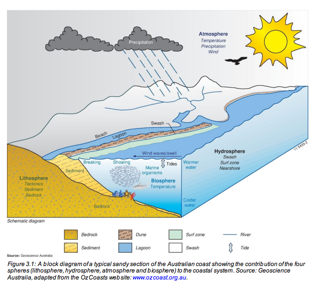
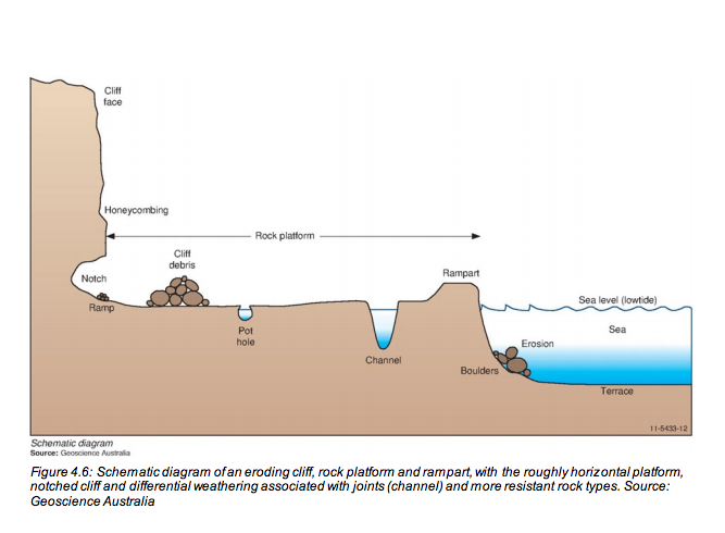
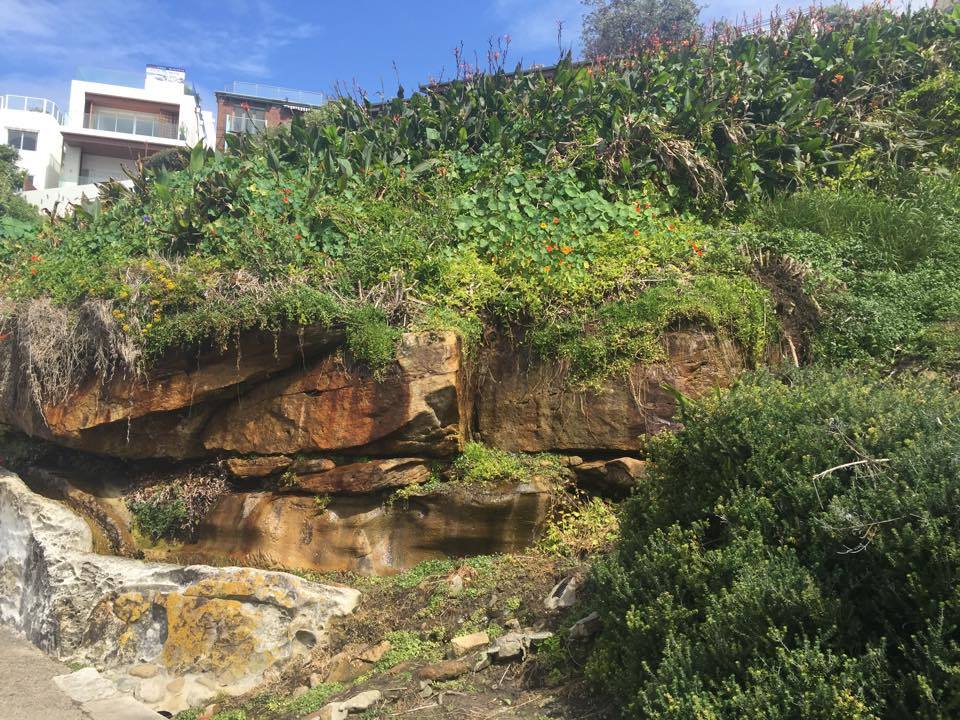
Use the images to help you undertsand different landform processes.
Activity 2. Natural hazards
Watch the video and visit the links above to help you answer the following questions.
Questions:
- Name one natural hazard?
- How can it impact the land?
- Explain how it may imapct human interaction.
- Describe the economic impact of the hazard in Australia.
- Describe the enviornmental impact of the hazard.
- Describe some consquences of the natural hazard.
- Find secondary infortmation to investigate the community responses to the natural hazard.
REMEMBER TO KEEP SAVING YOUR DOCUMENT SO YOU DON'T LOSE ANY WORK!
Lesson 3- Flora and Fauna
[video:https://www.youtube.com/watch?v=arFTh56-DVA]
Make use of the websites provided to assist you in answering the questions.
http://coastalcare.org/educate/flora-and-fauna/#beach-vines
http://www.waverley.nsw.gov.au/environment/water_and_coast/marine_envir…
Activity 1.
- From the videos, websites, and images provided, identify and list as many flora and fauna as you can.
- How do they impact the land?
Activity 2.
- Produce a sketching of a coastline plant and create a profile
- Produce a sketching of a fauna on this coastline.
Explain how the above flora and fauna have adapted to the environment.
REMEMBER TO KEEP SAVING YOUR DOCUMENT SO YOU DON'T LOSE ANY WORK!
Lesson 4- Human Interaction
Watch the video to assist you in answering the questions.
[video:https://www.youtube.com/watch?v=abU02rmVsKA]
[video:https://www.youtube.com/watch?v=_zLM9YDqEC0]
Activity 1. Visit the websites below to collect secondary information and answer the following questions in the same Word document.
http://www.skwirk.com/p-c_s-16_u-140_t-414_c-1451/coastal-management/ns…
http://www.environment.gov.au/heritage/places/national/bondi
http://www.waverley.nsw.gov.au/__data/assets/pdf_file/0009/42786/Waverl…;
Questions:
1. What is the interrelationship with humans and this coastline?
2. Identify human interactions with the area.
3. How does the land impact human interaction?
4. Outline how human interactions can cause distruptions to the natural cycles.
5. What impact does recreation and tourism cause to the coastal areas?
6. How can we sustain coastal managment ?
7. Explain how social life has changed over time.
8. List the positive and negative aspects of human interaction at Bondi to Coogee coastline. Use the secondary sources and your virtual field work to support your answers. (Hint:Consider human activities and attractions).
Activity 2. Climate change
Collect information and datato complete the activity.
http://www.waverley.nsw.gov.au/__data/assets/pdf_file/0009/42786/Waverl…;
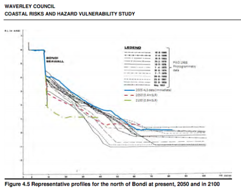
- Find a map of Bondi coastline from 2001 and a current map -identify and explain the changes in both maps. (Hint: both natural and physical changes).
- Describe what you think will happen to the coastline in the year 2050.
- With the information provided write a paragraph to explain how the climate change has impacted the coastline and human activities.
REMEMBER TO KEEP SAVING YOUR DOCUMENT SO YOU DON'T LOSE ANY WORK!
Evaluation
|
Criteria |
Mark |
information relating to the coastal management of an area chosen for investigation •Analyses the evidence to draw accurate and logical conclusions and relates the implications to the coastal management issue under study •Presents a detailed written report that clearly identifies and communicates geographical information associated with the coastal management of an area chosen for investigation |
20-25 |
|
•Uses geographical tools to identify and gather information relating to coastal management of an area chosen for investigation •Identifies evidence and draws some accurate conclusions, relating the implications of this evidence to the coastal management issue under study •Presents a written report that clearly identifies and communicates geographical information associated with the coastal management of an area chosen for investigation |
15-20 |
|
•Uses some geographical tools to gather information associated with coastal management of an area chosen for investigation •Collects some evidence and makes some deductions from the evidence which relate to the coastal management issue under study •Presents a written report that identifies and communicates some geographical information about coastal management of an area chosen for investigation |
10-15 |
|
• Demonstrates limited use of geographical tools •Makes some observations about coastal management and draws simple conclusions about the geographical issue from the information collected •Presents a written report that describes the research undertaken and/or the area chosen for investigation |
5-10 |
|
•Records some information about a coastal area being investigated •Makes limited observations of a coastal area being investigated •Presents a report that provides a description of a coastal area |
0-5 |
Conclusion
Congratulations on completing your geography fieldwork on one of Australia's iconic physical environments. Through this virtual fieldwork study of Bondi to Bronte Coastal walk and an analysis of the environment, you should now have a greater understanding and be more knowledgable about the issues in the physical characteristics of natural envrionments.
Make sure you save and keep all your works in a Word document, including answers and sketeches, maps, photographs.
We hope you enjoyed this virtual fieldwork and gained some knowledge to take with you.
Upon completion of this virtual fieldwork, students will have achieved the following outcomes:
5.1 identifies, gathers and evaluates geographical information
5.2 analyses, organises and synthesises geographical information
5.3 selects and uses appropriate written, oral and graphic forms to communicate geographical information
5.4 selects and applies appropriate geographical tools
5.7 analyses the impacts of different perspectives on geographical issues at local, national and global scales
5.8 accounts for differences within and between Australian communities
5.10 applies geographical knowledge, understanding and skills with knowledge of civics to demonstrate informed and active citizenship