Introduction
Welcome, Junior Explorers!
The Caribbean is known for its warm climate, beautiful beaches, and tropical weather. But have you ever wondered why Jamaica is warm while other places on Earth are freezing cold?
Your mission is to explore the imaginary lines called lines of latitude and discover how they help people understand climate and location around the world.
You and your team will travel virtually around Earth to investigate the Equator, Tropics, Polar Regions, and climate zones. By the end of this mission, you will explain how latitude affects temperature and locate Jamaica within the tropical zone.
Task
Your team has been hired by the “World Geography Organization” to create a Climate and Latitude Guide for young travelers.
Working in groups, you will:
-
Research the major lines of latitude.
-
Discover the different climate zones of Earth.
-
Locate Jamaica and the Caribbean on a world map.
-
Explain how latitude affects climate.
-
Create a poster, slideshow, brochure, or digital presentation.
Your final project must include:
-
A labeled map or diagram of Earth
-
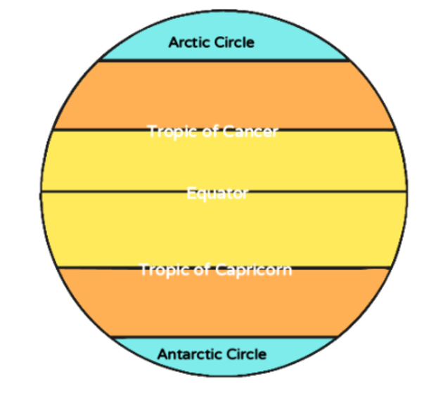
The Equator, Tropic of Cancer, Tropic of Capricorn, Arctic Circle, and Antarctic Circle
-
The Tropical, Temperate, and Polar Zones
-
Pictures or illustrations
-
An explanation of Jamaica’s climate
Process
Step 1 Meet the Lines of Latitude
Visit these websites and learn about latitude:
Answer these questions:
-
What are lines of latitude?
-
Which line is found at 0°?
-
Which latitude line passes closest to Jamaica?
-
Why are these lines important?
Step 2 Explore Climate Zones
Research the Earth’s climate zones.
Complete the chart below:
|
Climate Zone |
Location |
Temperature |
|---|---|---|
|
Tropical Zone |
||
|
Temperate Zone |
||
|
Polar Zone |
Then answer:
-
Which climate zone does Jamaica belong to?
-
Why is Jamaica usually warm?
Step 3 Become a Map Expert
Using a globe, atlas, or online map:
-
Draw and label the major lines of latitude.
-
Shade the Tropical Zone red/orange.
-
Shade the Temperate Zones green/yellow.
-
Shade the Polar Zones blue.
-
Mark Jamaica with a star
 .
.
Step 4 Team Presentation
Work together to create ONE final presentation.
Each group member must have a role:
|
Role |
Job |
|---|---|
|
Researcher |
Finds information |
|
Recorder |
Writes notes |
|
Designer |
Creates visuals |
|
Presenter |
Shares findings |
Evaluation
|
Criteria |
Excellent (4) |
Good (3) |
Satisfactory (2) |
Needs Improvement (1) |
|---|---|---|---|---|
|
Research |
Accurate and detailed |
Mostly accurate |
Some correct facts |
Limited information |
|
Teamwork |
Worked cooperatively |
Worked well most times |
Needed reminders |
Did not cooperate |
|
Map/Diagram |
Fully labeled and neat |
Mostly complete |
Some labels missing |
Incomplete |
|
Presentation |
Clear and creative |
Mostly clear |
Somewhat organized |
Difficult to understand |
Total: 16 marks
Conclusion
Congratulations, Explorers!
You have successfully completed your Latitude Mission and discovered how imaginary lines help us better understand the Earth and the world around us. Throughout this journey, you explored the major lines of latitude, including the Equator, Tropic of Cancer, Tropic of Capricorn, Arctic Circle, and Antarctic Circle. These important lines help geographers locate places on the Earth and understand how different regions experience different types of climate.
You also learned about the various climate zones found across the world, such as the tropical, temperate, and polar zones. By studying these climate regions, you now understand why some places are hot and rainy while others are cold and dry. In addition, you discovered why Jamaica has a tropical climate. Because Jamaica is located close to the Equator, it experiences warm temperatures throughout the year along with periods of rainfall that support the island’s rich vegetation and natural beauty.
During this mission, you also learned how geographers use maps and latitude lines to study the world, locate places, and better understand the relationship between people and their environment. These skills are important because they help us explore our planet, understand weather patterns, and learn more about different countries and cultures.
As you continue your learning journey, remember that geography is all around us and there is still so much more to discover about our amazing planet. Keep exploring, asking questions, and learning new things about the world we live in!
Credits
This WebQuest was created using information from a lesson plan that I created on lines of latitude. Additional information and learning materials for this WebQuest were adapted from classroom resources, educational websites as follows below and teacher-prepared materials on the metamorphosis of a story. All charts, images, and ideas are used for educational purposes.
Teacher Page
Overview
This WebQuest is designed for Grade 5 Social Studies students to develop their understanding of lines of latitude, climate zones, and location through inquiry-based learning and technology integration. Students will work collaboratively as “Junior Geographers” to investigate the major lines of latitude, explore how latitude affects climate, and locate Jamaica and the Caribbean on regional and world maps.
The WebQuest encourages students to use critical thinking, map-reading, teamwork, and research skills while completing interactive online activities and creating a final presentation. Through guided exploration, students will discover the relationship between latitude and temperature and understand why different regions of the Earth experience different climates.
This activity supports student-centered learning by allowing students to explore information independently while the teacher acts as a facilitator. It also integrates technology with Social Studies to make learning engaging, meaningful, and interactive.
Grade Level
Grade 5
Subject
Social Studies
Duration
60 minutes
Theme
The Physical Environment and its Impact on Human Activities
Focus Question
How do lines of latitude help us understand climate and location?
Objectives
Students should be able to:
-
Define lines of latitude
-
Identify the major latitude lines
-
Explain climate zones
-
Locate Jamaica and the Caribbean
-
Work collaboratively
-
Create a labeled Earth diagram
Attainment Target:
Understand the processes and forces that have formed the physical and built environment.
Strand:
Spatial Awareness and Environmental Understanding
How the WebQuest Supports the Curriculum
This WebQuest helps students:
-
Develop map-reading and atlas skills
-
Identify and locate the major lines of latitude
-
Understand how latitude influences climate
-
Locate Jamaica and the Caribbean on world and regional maps
-
Interpret information from maps, globes, and online resources
-
Work collaboratively to solve problems and share findings
The activities also support the development of important 21st-century skills, including:
-
Critical thinking
-
Communication
-
Collaboration
-
Creativity
-
Technology integration
-
Research skills
Students actively engage in inquiry-based learning while exploring real-world geographical concepts connected to climate and location